Let's take an example: Chicago. Experts forecast that Chicago "could expect 35 percent more precipitation in winter and spring, but 20 percent less in summer and fall." This explains why within its recent master plan, Chicago deploys efforts to reinvent itself to improve quality of life of its residents as well as workplaces.
 |
| FibroCity, Houston, United States of America © Perkins + Will |
Another case concerns directly urban planning, or a lack of effective urban planning. This second factor is the core of this post: Cities regeneration. Houston is symptomatic of errors in terms of urban planning. Precisely, Houston appears to lack effective city "tools". It has been made up based upon a one-size-fits-all urban planning. This results in urban spaces suffering of fragmentation due to the intrusion of highways in response of an increasingly use of cars. Houston is an example of automobile-dependent metropolitan regions. The lack of effective urban planning leads to serious impacts of congestion and air pollution in relation with cars. As it is often highlighted, it is no more possible to make up a city as we made in the modern era. As the city becomes dense, problems of lack of urban planning tend to become prominent — air quality, congestion as well as flooding, fragmented development, etc.
Recently, a new vision of making-city arises from a reflection on the future of Houston. A new version that highlights the ambition of implementing a better urban planning based on a clear framework to guide quality of life, sustainable growth and changing contexts. The city attempts to operate a transition to a walkable, transit-served urbanism, a city made for its residents and no more for cars. In other words, Houston attempts to shift into a 21st century City that considers quality of life and of course economy as the key element. Quality of life that means a healthy, self-sufficient, environmentally friendly city.
Connection — or Reconnection — is the keyword to understand FibroCity, the project that Perkins + Will just unveiled with the ambition of making Houston a "walkable" transit-served city. Before going deeper into the examination of FibroCity and ResilienCity, Perkins + Will's proposal would operate in a 15-acre site, a portion of Houston urban space that illustrates the city's one-size-fits-all-type of urban planning. The FibroCity consists of a proposal based on interwoven programmatic elements. It aims at regenerating the urban voids created with the intrusion of highways into the urban environment by filling with effective programs. Perkins + Will confirms the issues that Houston faces: lack of zoning code, traffic congestion, lack of public transit, air and water quality, poverty, discontinuity, and obesity. Perkins + Will's FibroCity is a city based on communication networks, exchange such as fibers to regenerate the fragmented urban space of Houston. FibroCity proposal is conceived to provide people space to "avoid the street and vehicular traffic". It is also a proposal that integrate nature areas in the city; it helps the city to retrofit to a self-sufficient city.
Streets will have the crucial role of re-connector "tools" of urban areas. As I mentioned, the highways-oriented city of Houston led to urban areas that were segregated. Houston new master plan calls for the adoption of a smart citywide infrastructure and drainage plan based on national quality standards. Say complete streets. Complete streets in the sense that these streets must be designed for transit, pedestrians, parking, bicycles, landscaping and well-located utilities while streets were conceived originally just for cars and drainage.
 |
| Complete streets © Perkins + Will > One of major problems from which Houston suffers, according the website Better Houston is the lack of organisation of its streets. Streets are mainly designed for cars and drainage. Along with Perkins + Will's design proposal, streets will be "completed" with the extension of their use to pedestrians, bicyclists, and landscaping, so forth. These "great" streets will also become "greenways". |
These greenways will precisely be made up artificial and natural environment, say paths and nature. Trees will be planted to provide shading for the pedestrians. They will have the delicate task to regenerate air quality of Houston.
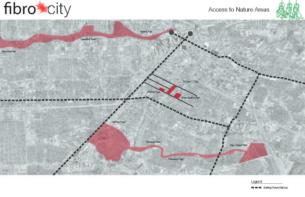 |
| Diagram — Access to Nature areas © Perkins + Will |
A canopy will be built to allow people for a range of views and experiences through the site.
 |
| Canopy © Perkins + Will |
 |
| Under the Canopy © Perkins + Will > The canopy is a good illustration of Houston's effort for the integration of landscaping in its urban environment. The canopy will house green promenade and parks. It will facilitate the diffusion of natural air and sunlight within the green areas. |
Urban voids will be replaced by various programs, such as urban agriculture and exchange areas.
 |
| Diagram — Urban Agriculture and Habitat Exchange Areas, © Perkins + Will > The intrusion of nature areas and habitat can help reconnect the fragmented spaces by filling the urban voids. |
 |
| Diagram — Net Zero Energy © Perkins + Will > The sustainable strategy will consist of a solar system that combined heat and power strung engine generators with no combustion. It will also incorporate other systems such as photovoltaic panels and wind turbines. |
 |
| Diagram — Net Zero Water: Grey Zero Water © Perkins + Will |
 |
| Diagram — Zero Net Water: Black Water Process © Perkins + Will |
Globally the Innovation District which is part of South Boston redevelopment envisions a new type of urban planning. As the Boston Redevelopment Authority (BRA) underlines, Boston's current zoning reflects " a time when industrial uses were more prevalent along the corridor." In other words, Boston's current urban planning mainly does not correspond to the changing contexts. It does "not reflect the natural spread of residential uses into this area from the traditional South Boston residential neighborhood." The task is to develop a clear vision based on a mixed use zoning district for the area. The Boston's Innovation District new master plan envisions to provide test of groundbreaking technologies in clean energy, citizen participation, transportation, and city infrastructure.
 |
| ResilienCity, Boston, USA © Mab-Lab |
This is the framework of Map-Lab's ResilienCity. Map-Lab participated in the International Living Future Institute's Living City Design Competition 2010 that sought designs for cities in the 2035. ResilienCity seeks to invite citizen participation — a community — to "create environments that are culturally enriching, healthier, and equitable." It contains "new canals that give100 acres of land back to the sea and provide for roof gardens and living walls throughout the district with the goal of re-establishing long lost ecological conditions."
ResilienCity design proposal consists of over 15 million square feet (1393545.6 square meters) of green spaces for recreation and green roofs.
|
| ResilienCity © Map-Lab |
ResilienCity articulates Water, Energy, Health, Materials and Beauty. Water, first. Map-Lab's net zero strategy integrates the transformation of an existing bus tunnel into a 20 million gallon district water cistern. The goal is the restoration of existing hardened edges (granite seawalls) into permeable surfacing that allow for aquifer recharge through reconstructed wetlands.
 |
| Infrastructure Section © Map-Lab |
Map-Lab's energy strategy will propose 4 times what is required in the district by using a variety of processes including photovoltaic systems on building roofs and the roads, biogas using organic waste, and MicroCHP strategies at individual building scales. As for Health, this part is unclear for me. It requires to be developed or, at least, more details. According to the architects, ResilienCity will encourage all visitors, workers, and occupants to be active and educated about their health. It is not specified which practical strategies will be drawn to help people to be active and educated about their health. Nonetheless, the design proposal propose to reduce substantially the vehicular traffic. In contrast, public transit system will be increased and improved by relocating the tractor-trailer trucks to a new Eco Industrial Zone.
 |
| ResilienCity — Mixed Use District Section © Map-Lab |
Materials consist of the reuse of existing buildings and a self-imposed limitation of 500 km radius for sourced materials. Each building will be equipped with a building nutrition label providing nutritional value to residents. This system will provide information about energy, water and waste.
 |
| Home Section © Map-Lab |
Beauty, finally, will consist of educational opportunities about nature, health, buildings and community. A model that encourages the engagement and tracking activities will be created. This is a 'carbon card" as an embedded synthesis of the economic (debit card) and the ecological (embodied energy factors) "costs' of things, as the agency says.
 |
| ResilienCity © Map-Lab |
This will be a device, as an evolution of smart phone technologies, that will provide the residents' ID card, communications, data accessing device, credit/debit card, embodied energy measurer as well as their health status.
 |
| ResilienCity Site Plan — Aerial view © Map-Lab |

No comments:
Post a Comment